How Williams Lake Residents Can Prepare Their Homes and Families for Wildfire Season

Are you confident your family knows exactly what to do if the evacuation sirens sound again in Williams Lake? If you lived here during the summer of 2017, you remember the thick smoke, the tension in the air, and eventually the order to pack up and leave as wildfires threatened our city. For eleven days, our community scattered across the province while firefighters battled to protect what we'd built. That experience changed how many of us think about preparedness — and it should.
Living in the Cariboo means accepting that wildfire season is part of our reality. The forests surrounding Williams Lake are beautiful, but they're also fuel. When conditions align — hot, dry, windy — it doesn't take much to spark a fire that moves faster than you can pack your truck. The good news? There's plenty we can do right now, before the grass turns brown and the fire danger ratings climb, to protect our homes and keep our families safe.
What Makes the Williams Lake Area Particularly Vulnerable to Wildfires?
Williams Lake sits in a geographic pressure cooker when it comes to fire risk. We're surrounded by vast forests of pine and spruce that can burn intensely once ignited. The climate here has shifted over the past decades — summers arrive earlier, stay hotter, and bring less precipitation. When lightning strikes the hills west of town or a spark flies from equipment working in the backcountry, we've got the perfect conditions for rapid fire growth.
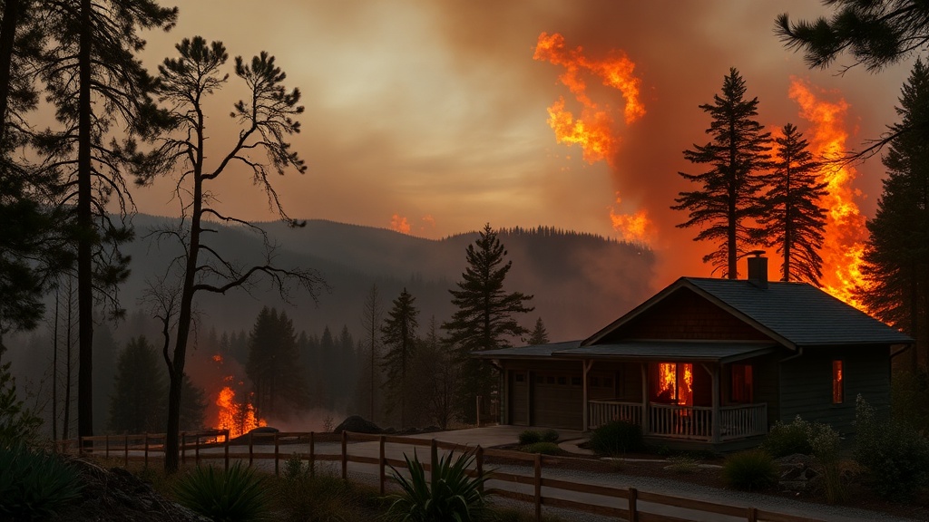
The 2017 wildfire season taught us hard lessons. The Elephant Hill fire alone burned over 192,000 hectares and forced the evacuation of our entire city. Residents lined up on Highway 97, some heading north to Prince George, others south toward Kamloops, not knowing if they'd have homes to return to. Fire crews made a stand at the Williams Lake Airport — yes, that airport right off Highway 20 — and managed to hold the line. But it was close. Too close.
Since then, the Cariboo Fire Centre has increased its resources and improved early detection, but the reality hasn't changed: when a big fire approaches, we may have hours — sometimes minutes — to get out. Understanding this vulnerability isn't about living in fear. It's about respecting the place we call home and taking sensible steps to protect it.
How Can You Create a Defensible Space Around Your Williams Lake Property?
Your first line of defense starts at your property line. FireSmart Canada — the national program for wildfire preparedness — recommends creating what's called a "defensible space" around your home. This isn't about clearing everything bare; it's about managing vegetation strategically so that if a fire approaches, your house has a fighting chance.
Start with the immediate zone — the first 1.5 meters around your house. Remove anything that can burn easily: dry leaves in your gutters (clean those out in spring!), wooden planters touching your siding, firewood stacked against the wall, that decorative bark mulch that goes up like gasoline. Replace it with non-combustible materials: gravel, river rock, or concrete pavers. The homes that survived the 2017 fires often had one thing in common — nothing flammable right against the exterior walls.
Move out to the intermediate zone, extending about 10 meters from your walls. Here, you want to break up continuous vegetation. Thin out trees so their crowns don't touch — aim for at least 3 meters of space between the tops of mature trees. Prune branches up to 2 meters from the ground so ground fires can't climb into the canopy. Mow grass regularly during fire season; tall, dry grass burns fast and hot. If you've got property along the Fraser River corridor or back onto Crown land west of town, this zone becomes even more critical.
The extended zone stretches from 10 to 30 meters out. You don't need to eliminate trees here, but you should reduce the density and remove deadfall. Think park-like — scattered trees with space between them, ground cover that's green and growing rather than brown and crispy. If you're unsure where to start, the Williams Lake Fire Department occasionally offers free FireSmart assessments for city properties. Call them at (250) 398-2341 and ask about booking an evaluation — they'll send someone out to walk your property with you and identify specific risks.
What Should Your Williams Lake Emergency Go-Bag Include?
When the evacuation order comes, you won't have time to run around the house gathering essentials. That's why every household in Williams Lake needs a go-bag — a backpack or duffel packed and ready by the door, preferably one per family member. I've talked to neighbours who spent precious minutes during the 2017 evacuation frantically searching for prescription medications and pet carriers while the sky turned orange. Don't be that person.
Start with the basics: three days of water (4 liters per person per day), non-perishable food, a first-aid kit, flashlights, extra batteries, and a battery-powered radio. Include copies of important documents — insurance papers, identification, bank records — sealed in a waterproof bag. Cash is crucial; if power's out, ATMs don't work and card readers are useless. Pack enough for gas, food, and a few nights at a hotel.
Personal items matter too. Medications (rotate these out so they don't expire), eyeglasses, comfort items for kids, leashes and carriers for pets. If you have livestock or horses on acreage outside city limits, you need a separate plan — know which neighbour can help trailer your animals, or identify the evacuation routes to the Williams Lake Stampede Grounds, which sometimes serves as a livestock evacuation centre during emergencies.
Don't forget seasonal considerations. Williams Lake winters are cold; pack warm layers even if you're evacuating in July — mountain weather changes fast, and you might end up sleeping in your vehicle. A good pair of boots, rain gear, and blankets round out the kit. Store the whole thing somewhere accessible, and make sure everyone in your household knows where to find it.
Where Can You Get Real-Time Wildfire Updates for Our Region?
Information during a wildfire emergency moves fast, and bad information moves faster. During the 2017 evacuation, rumours spread like — well, like wildfire. Social media was full of unverified reports about which roads were open, which neighbourhoods were threatened, where to find gas. Some of it was helpful; some caused panic.
The authoritative source for fire information in our area is the BC Wildfire Service. Their website publishes real-time maps showing active fires, evacuation alerts and orders, and fire danger ratings specific to our fire centre. Download their app or bookmark the site on your phone. Sign up for the Emergency Info BC alert system — this is the official channel for evacuation notices.
For local context, follow the City of Williams Lake's official accounts on Facebook and X (formerly Twitter). The city's emergency operations centre coordinates with provincial authorities and posts verified updates about road closures, evacuation centre locations, and services available to displaced residents. The local radio stations — Cariboo Country Radio (CKWL) and 94.3 The Goat — also broadcast emergency information and often have reporters on the scene providing context you won't get from official sources.
If you're in one of the rural areas surrounding Williams Lake — Sugar Cane, Soda Creek, 150 Mile House — pay attention to the Cariboo Regional District's alerts too. The CRD covers the broader area outside city limits and issues separate evacuation notices for those zones. Know which jurisdiction you live in; it determines who will contact you in an emergency.
How Do You Know When It's Time to Leave?
Here's a truth that doesn't get talked about enough: waiting for an official evacuation order can be dangerous. By the time authorities issue an order, the fire may already be cutting off escape routes. Smart residents pay attention to evacuation alerts — the warning stage before an order — and use that time to get ready. Better yet, leave early if you feel unsafe. No one will judge you for prioritizing your family's safety.
If you receive an evacuation alert, take it seriously. Pack your vehicle, gather your pets, prepare your property (turn off propane tanks, close windows and doors, move flammable furniture away from windows), and be ready to go at a moment's notice. Monitor official channels constantly. If you have family members with mobility challenges, young children, or livestock that needs transport, consider leaving during the alert phase rather than waiting for a mandatory order.
When the order comes, go immediately. Take your predetermined route — ideally, you should have two planned, one heading north and one heading south, since you don't know which direction the fire will approach from. Stick to main highways; back roads may be blocked or unfamiliar. If you're heading toward Prince George, Highway 97 north is your route. Southbound, you'll take Highway 97 toward Kamloops. Keep your gas tank above half full during fire season so you never start an evacuation on empty.
Don't try to save your possessions — they're not worth your life. The homes that burned in 2017 weren't lost because people didn't fight for them; they were lost because the fire was simply too intense. Professional firefighters with heavy equipment and air support couldn't stop it in places. Your garden hose never stood a chance. Get out, stay out, and trust that our community will help you rebuild when the smoke clears.
Preparedness isn't paranoia — it's respect for the place we live and love. Williams Lake has survived worse than wildfire. We've got neighbours who check on each other, volunteers who staff evacuation centres, and a resilience forged through shared hardship. Do the work now — clear that defensible space, pack that go-bag, sign up for those alerts — so that if next summer brings smoke to our skies again, you'll be ready. Our community depends on every one of us being prepared.